Current Research
Scaling in Hydrology from Pores to Basins
Principle Investigator: Alex Rinehart
Internal collaborators: Susan Bilek, Glenn Spinelli, Brian Borchers
External collaborators: Ronni Grapenthin (Geophysical Institute, UAF), Jeff Kennedy and Andrew Robertson
Societies are using groundwater that is thousands of years old at beyond basin scales, but are still measuring groundwater at the point scale and thinking of time with only a handful of tools. At the same time, the water cycle itself is constantly changing the amount of water entering and leaving groundwater at a multiplicity of time scales. These challenges are foundational to the field of hydrology, caused by large variations in permeability and the presence of faults and fractures. And they are a primary source of uncertainty in water management.
 Hydrologists "fill in" the gaps using numerical models, but we do not have ways of
linking predictions across those scales to measurements. But we are beginning to be
able to bridge these scales by linking hydrological models and observations to geodetic
(surface deformation and gravity) measurements.
Hydrologists "fill in" the gaps using numerical models, but we do not have ways of
linking predictions across those scales to measurements. But we are beginning to be
able to bridge these scales by linking hydrological models and observations to geodetic
(surface deformation and gravity) measurements.
These new methods hold the promise to:
- Find boundaries in groundwater levels away from well networks, or possibly even in fractured mountain blocks.
- Estimate and predict aquifer properties, particularly the hard-to-define storage coefficients that measure how much water an aquifer can hold, at the scale of basin- scale management.
- Provide realistic, correct data to test and improve regional (10-s to 100s km) models in near-real time.
- Identify problems such as subsidence, drawdown, leaking boreholes, and changes in mountain water storage before they become significant hazards, independent of other monitoring.
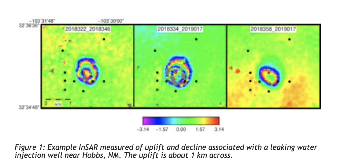
Example InSAR measured of uplift and decline associated with a leaking water injection well near Hobbs, NM. The uplift is about 1 km across.
Hydrogeodesy - bridging process and scales in space
There are two sets of geodetic methods to understand changes in underground water storage: monitoring changes in mass by gravity methods, and using the deformation caused by changes in fluid pressure and potentially flexure resulting from large mass movements. Currently, satellite-based gravity measurements (GRACE) can monitor storage changes at 10,000 sq km scales every month, and land-based gravity measurements can monitor storage changes at 10s to 100s m scales intermittently. One set of surface deformation measurements are continuous point measurements (GPS, tiltmeters and strainmeters) that, because of how fluid pressure couples with deformation, responds at the scales of 10s to 1000s m.
In addition, interference signals on GPS measurements can be interpreted for snow water and soil moisture at the surface at the 10s m scale. Radar satellite measurements of surface deformation cover larger swathes of the landscape (100s m to 10s km) but at monthly to yearly intervals.
These measurements are above the scale at which we measure groundwater, but are at the scale at which we manage groundwater. But before we can use geodesy to manage groundwater, several engineering and science hurdles remain.
 Linking hydrologic and mechanical deformation in practice
Recent SihP results and results from other groups show that, yes, we can measure hydrologically caused deformation and gravity changes. However, the field of hydrogeodesy is young and rapidly developing so fundamental questions still remain, including basic problems about which hydrologic signals geodetic tools can measure.
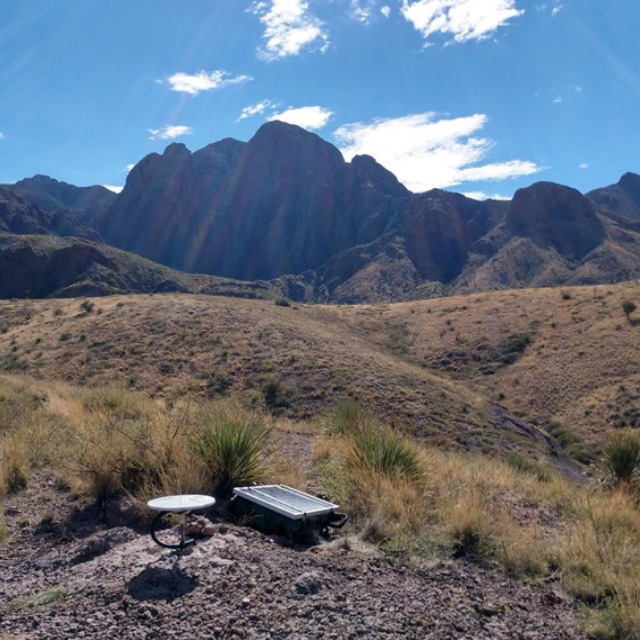
Currently, SihP is working on four projects focused on using tilt, GPS, InSAR and repeat terrestrial gravity to understand what is possible and how geodetic techniques can bridge scales in groundwater changes.
Moving forward, SihP will continue to seek funding for deploying geodetic networks around existing hydrologic monitoring networks to understand the range of possibilities in this new field. This includes seeking funding with partners from UAF, the USGS, and for instrumenting metropolitan and intensively irrigated agricultural areas, near different classes of rivers to understand surface water-groundwater interactions, and in mountainous landscapes to explore the decoupling of regional flexure responses from local signals.
New sensors and sensor networks
Recent research has revealed that current geodetic techniques will likely need multi-sensor networks, involving relatively expensive sensors. This is especially the case for terrestrial gravity, despite recent advances in technology.
In addition to the sensor networks we are deploying currently, we will undertake GPS sensor intercomparisons, testing new, less expensive technologies against current sensors, and will seek funding to design new, low-cost but high-precision gravimeters.
In the long-term, cost will be a primary limiting factor in applying these technologies.
AI and lab-based physics discovery
The current state-of-the-art for modeling in hydrogeodesy consists of either forward modeling predictions or manual calibration coupling groundwater flow and poroelasticity. However, these remain limiting because of the complexity and scale-dependence of the physics, and uncertainty of material parameters.
We propose to use artificial intelligence approaches to discover "new" scale-dependent physics and to automatically constrain material parameters, making future large-scale applications possible.
And we propose to use densely instrumented scaled 3D-printed models of porous and fractured media, as well as larger scale systems (basins and mountain ranges) to test our understanding of the scaling of poromechanics to hydrogeodetic and water management scales.
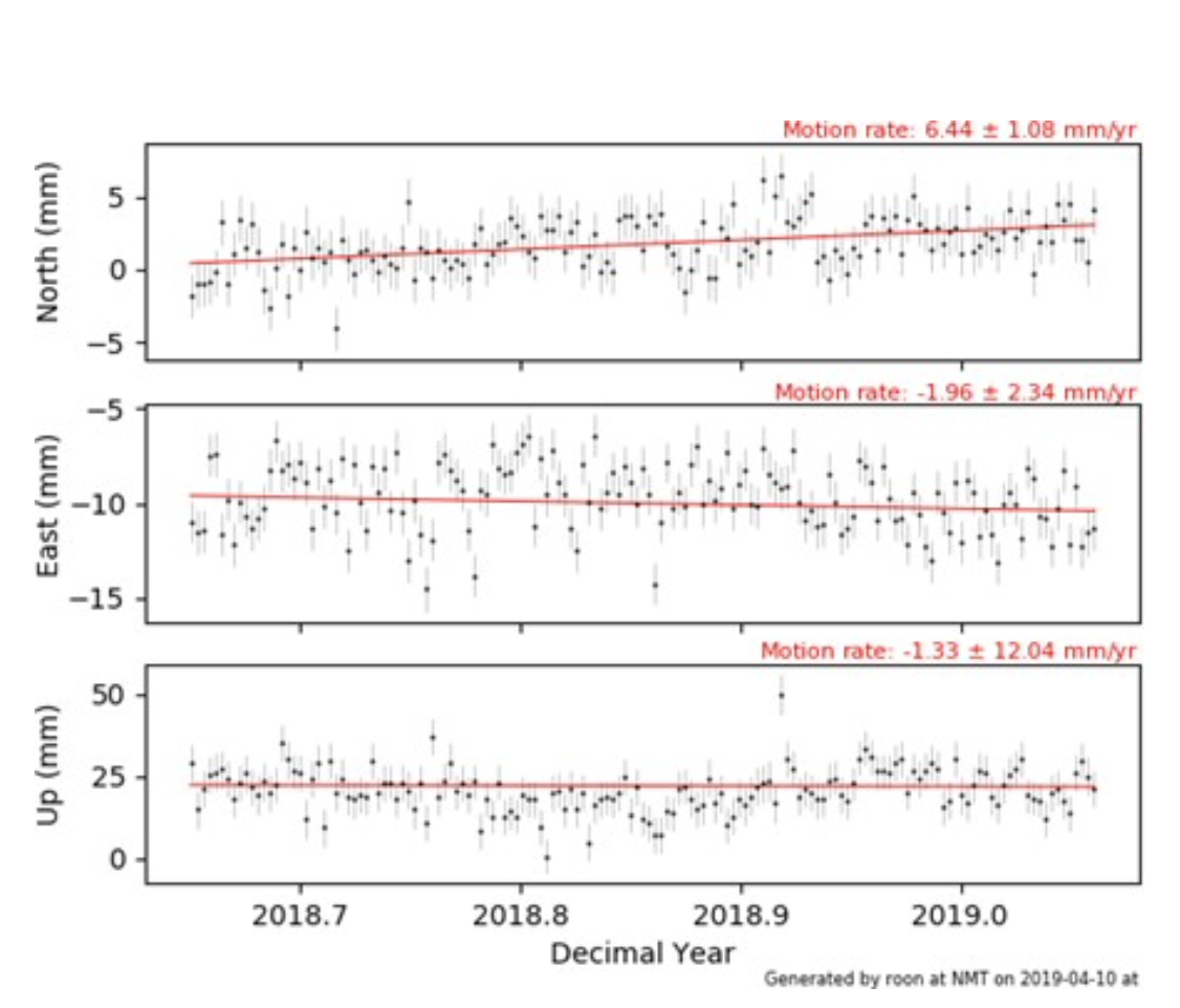
Example GPS position times series from the valley near Las Cruces showing flexure on monthly and weekly time scales
Proposed collaborators and sites: Albuquerque Bernalillo County Water Utility Authority and MRGCD, City of Santa Fe, EBID and City of Las Cruces
Proposed funding agencies: NSF, NASA, NM State, DARPA, DOE BES, DOE Geothermal, DOE Office of Fossil Fuels
Navajo Nation Water Purification Project (N4WPP)
Navajo Technical University & New Mexico Tech
 A joint endeavor to install water filtration equipment testing facilities on the Navajo
Nation. These sites will be used to train students to test water quality and maintain
filtration units to provide sustainable long-term water resources suitable for agriculture
and livestock use, cleaning, and eventually clean drinking water.
A joint endeavor to install water filtration equipment testing facilities on the Navajo
Nation. These sites will be used to train students to test water quality and maintain
filtration units to provide sustainable long-term water resources suitable for agriculture
and livestock use, cleaning, and eventually clean drinking water.
Climate & Water Consortium (CWC)
New Mexico Tech
An innovative problem-solving center for interdisciplinary research and outreach. Bridging biology, physics, atmospheric physics, engineering, hydrology, geophysics, chemistry, applied math, economics, computer science, and education. A way to use science to solve overarching problems, in particular applied to weather prediction, climate change, water management, and high technology.
Development of 3D Aquifer Maps
New Mexico Bureau of Geology and Mineral Resources
The New Mexico Bureau of Geology and Mineral Resources has begun the important task of mapping the major groundwater aquifers of our state in three dimensions. These 3D aquifer maps will focus on the accessible (<1000 ft), actively used groundwater resources, and will utilize existing data to develop the regional maps.
https://geoinfo.nmt.edu/resources/water/amp/home.html
Produced Water and Petroleum Engineering
Petroleum Recovery Research Center (PRRC)
Pursues advanced methods of treating oilfield-produced water through innovative membrane technology. Purification and filtration techniques aim to cleanse produced water into a viable resource for community and agricultural applications.