Storm Chase Club Follows Bad Weather Across Midwest
September 10, 2010
This year’s storm chase team consisted of several students and one alumni member, and found its most active days in Nebraska, Kansas and Colorado.
This year’s storm chase resulted in severe thunderstorms near Garden City and Oberlin
in Kansas, Lexington and Scotts Bluff in Neb., and Walsh, Colo. The storm near Walsh
produced two tornadoes, one of which was on the ground briefly (about 10 seconds),
and the other was on the ground for over 8 minutes. Video of this tornado can be found on YouTube. Thankfully, this tornado did no damage.
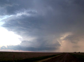
This tornado came from a supercell, which is a discrete storm cell that is rotating.
The rotation comes from wind shear, or differing wind directions with respect to height
in the atmosphere. Notice the photo that the whole storm appears to be spinning.
A thunderstorm gets its energy from the updraft region of the storm, where warm, moist
air rises quickly. A supercell differs from a typical summer thunderstorm because
in the case of a summer thunderstorm, there is little shear and the thunderstorm rains
down through its own updraft. In the case of a supercell, the shear allows the storm
to become more organized. By doing so, a supercell does not rain through its own updraft,
and thus persists for much longer and ends up being much stronger.
Besides seeing tornadoes, the chase team also saw several severe storms, including
a strong squall line just north of Lexington.
The fun part of the storm chase is watching a forecast come together. It is working
with limited data to predict a target area –then getting there before the storms form.
To find the storms, the chase team used sounding data from the National Weather Service
(NWS) and the convective outlooks from the Storm Prediction Center (SPC). Most mornings
started with warm temperatures, plenty of humidity, and under mostly sunny skies,
or “severe clear.” Each day, the chase team had to predict where to position themselves
in the Great Plains to see storms that would start forming six or seven hours later.
Predicting where and when there will be severe storms requires skill, and a lot of
luck. Often, the trick is to find the “triple point,” an area where all of the correct
elements are in place – and then let luck do as it will. The triple point is an area
where the dryline (a boundary between moist air and dry air), a frontal boundary and
upper level support (a short wave in the jetstream or a jetstreak) come together.
If these all come together perfectly, there will be ample shear, plenty of warm, moist
air, and available energy for storm development.
The trick is predicting when or if these things will come together. If these things
do not come together, then the trick is making the best of what is available – sticking
with a really strong dryline and frontal boundary, if no upper air support is available,
or perhaps using an outflow boundary (mini-cold front where rain-cooled air from another
weaker storm) when upper air support and a dry line are present. Some days, it’s not
even worth trying; if there is a good chance tomorrow in South Dakota, and a low chance
in Texas, it might be worth skipping Texas today to get in position for tomorrow in
South Dakota. These are the real decisions a chase team must make.
One common misconception with storm chasing is that storm chasers wait for a warning
to be issued, and then drive to where the warning was issued. This is not the case
at all. Often, storm chasers relay information to the National Weather Service (NWS)
to assist them with the decision to issue a warning. On each storm chase, the chase
team uses amateur radio and cell phones to update the NWS of any severe weather. Several
of the chase team members have participated in Skywarn, a volunteer organization trained
by the NWS to report severe weather.
The active season for storms is between early April and late June, when the atmosphere
settles into a more summer-like pattern. The Meteorology and Storm Chase Club will
be gearing up for weekend chases – short chases that will occur as weather permits
in the spring.
While Hollywood has exaggerated storm chasing into some sort of “extreme” sport, most
storm chasers will agree that real storm chasing is entirely different. A typical
weekend storm chase will be on the order of 1,500 miles in the car, fast food (or
even convenience store food) and a cheap hotel or two. In Twister, the object is to get as close to a tornado as possible. Real storm chasers know
that visibility is zero because it’s all blowing dust. Real chasers spend time farther
away from the storm to get a better view of what is going on.
In the movie Twister, the entire chase team is blasting Van Halen on the radio. When storms start to fire,
trade Van Halen for the hissing and popping of amateur radio and the NWS weather radio.
In Twister, the tornadoes are growling and hungry, yet in reality, a lot of real tornado footage
has birds chirping in the foreground. In Twister, there is non-stop action 95 percent of the time. In real storm chasing, there’s
non-stop driving 95 percent of the time, coupled with an occasional intense moment,
and maybe some sleep.
Those days where the storms form where you predicted make it all worth while. For
the rest of the time, storm chasing is about testing your own abilities as a forecaster
and learning from your mistakes. It’s about anxiously driving to places that most
people would prefer to fly over. It’s about the freedom of the open road and enjoying
where you are.
For more information about the New Mexico Tech Meteorology and Storm Chase Club, please
email Seth Price, sprice@nmt.edu , or check out the club website.
By Seth Price/New Mexico Tech