Bureau Geologist Is A Finalist In NSF "Vizzies" Competition
June 26, 2018
SOCORRO, N.M. -- Matt Zimmerer, field geologist at the Bureau of Geology (and an NMT grad) entered the National Science Foundations’ “Vizzies Challenge.”
 This competition is the NSF’s annual competition to select the top science and engineering
images and graphics. Zimmerer submitted an entry titled “A Drone’s View of Earth’s
Surface”.
This competition is the NSF’s annual competition to select the top science and engineering
images and graphics. Zimmerer submitted an entry titled “A Drone’s View of Earth’s
Surface”.
Zimmerer’s entry made it through the first two rounds of voting and is now a finalist.
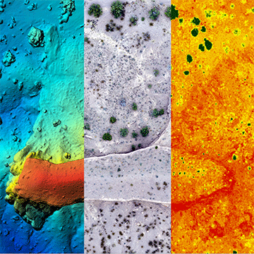
The image is a composite of three images taken by Zimmerer's drone of the mesa near San Lorenzo Canyon north of Socorro.
The left portion is an elevation map made with Structure in Motion using 2-D images to create a 3-D visualization. The red portions are the top of the mesa, while the blue portions are the canyon floor. The center image is an ortho-mosaic image that is similar to a Google Maps image. The right section is a "green-ness map," which shows concentrations of plants as dark spots.
Zimmerer created the image during a proof-of-concept flight that took only about 15 minutes.
Check out all the great illustrations and videos if you have the time at https://vizziesvote.skild.com/. You can also vote for your favorite images. (Matt’s entry, “A Drone’s View of Earth’s Surface" is pictured at right.)
You can learn more about the program and see previous winners on the home page here:
https://www.nsf.gov/news/special_reports/scivis/